Set Equatorial Scale
The Set Equatorial Scale command is a quick method for attaching a low-precision equatorial World Coordinate System ("WCS") to an image. The WCS allows the image to be examined and measured directly in units of Right Ascension and Declination. If the image is aligned with east-west parallel to the rows, and you know the image scale fairly accurately, the calibration should be good enough for applications requiring only moderately accurate distances and positions. You can create a high precision calibration using the Astrometric Calibration command.
Open this command from the View > World Coordinates pull-down menu.
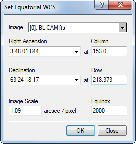
The WCS Calibration requires the information shown in this dialog: (Right ascension, Declination) at a reference (column, row), an Image Scale, and an Equinox. This command inserts these quantities into the image header to enable world coordinate system functionality. This command is usually used to make a low precision or approximate calibration so that measurements, plots, and cursor readout can use World Coordinate units of arcseconds.
This command applies a WCS calibration to the image or image set. This calibration replaces any existing WCS. However, this command creates an Undo copy so that you can use the Edit > Undo (Ctrl+Z) command to restore the previous coordinate system. If you want to save the Equatorial Scale calibration, save the image in the normal way.
|
Tip |
If the |
Astrometric Calibration, World Coordinate System, Image Coordinate System, Set Arcsecond Scale, Delete WCS