This command is operated using the Photometry Keywords page of the Aperture
Photometry Properties dialog. The dialog is opened by
clicking ![]() on the Aperture Photometry
toolbar..
on the Aperture Photometry
toolbar..
Photometry Keywords
The Photometry Keywords command is used to set keyword names used by the photometry tools to load Properties from the image headers. This command uses the dialog shown below. If these keywords are not present in the image headers, some of them that do not change can be set in the images using the Modify Keywords command.
This command is operated using the Photometry Keywords page of the Aperture
Photometry Properties dialog. The dialog is opened by
clicking ![]() on the Aperture Photometry
toolbar..
on the Aperture Photometry
toolbar..
x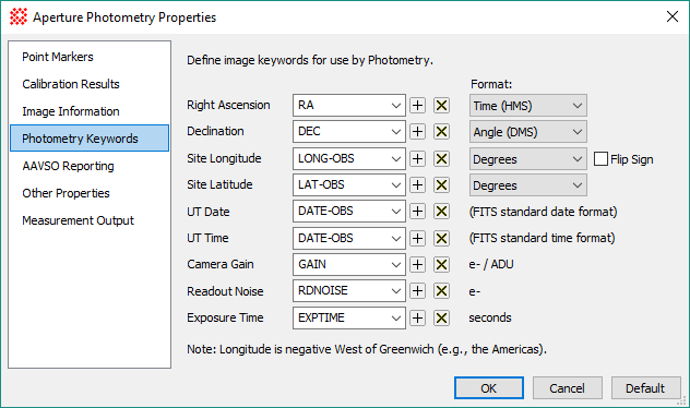
This dialog is used to set the FITS style header keywords and specify the format that certain keywords will use in your images. For some of these keywords, the format may be either an angle string or a value in decimal degrees.
The first 6 keywords are used for computing the airmass of the observation. If the airmass cannot be calculated, or if bad keyword values cause the value to be impossible, then the result is reported as 0.0 in the Apphot Pane.
The last 3 keywords are used for computing the photometric errors and zero point value.
|
Photometry Keyword Properties |
|
|
Right Ascension |
The right ascension coordinate in units of either decimal degrees or HMS. You must select the coordinate format from the adjacent list box. Decimal degrees is the standard FITS representation for angles. The FITS standard is for right ascension to be held in the CRVAL1 keyword and specified in decimal degrees. A common non-conforming usage is with the RA keyword and specified in HMS units, as hh:mm:ss.sss. |
|
Declination |
The declination coordinate in units of either decimal degrees or DMS. You must select the coordinate format from the adjacent list box. The FITS standard is for declination to be held in the CRVAL1 keyword and specified in decimal degrees. A common non-conforming usage is with the RA keyword and specified in HMS units, as dd:mm:ss.sss. |
|
Site Longitude |
The longitude of the observing location in units of either decimal degrees or HMS. You must select the coordinate format from the adjacent list box. Decimal degrees is the standard FITS representation for angles. The FITS standard is for longitude to be held in the SITELONG keyword and specified in decimal degrees. A common non-conforming usage is with the LONGITUD keyword and specified in HMS units, as hh:mm:ss.sss. NOTE: The longitude is negative west of the Prime Meridian at Greenwich, England (e.g., the Americas), as per the World Geodetic System specification WGS84. Incorrect longitude sign can be accommodated using the Flip Sign option. |
|
|
This option flips the sign of the longitude specified in the image header. Mira expects West longitude to be negative (see the description of "Site Longitude"). If west longitude is incorrectly specified as positive, or vice versa, check this box. |
|
Site Latitude |
The latitude of the observing location in units of either decimal degrees or DMS. You must select the coordinate format from the adjacent list box. The FITS standard is for latitude to be held in the SITELAT keyword and specified in decimal degrees. A common non-conforming usage is with the LATITUDE keyword and specified in HMS units, as hh:mm:ss.sss. |
|
UT Date |
The UT date of observation. The FITS standard is for date and time to be combined in the DATE-OBS keyword with the format yyyy-mm-ddThh:mm:ss.sss. |
|
UT Time |
The FITS standard is for date and time to be combined in the DATE-OBS keyword with the format "yyyy-mm-ddThh:mm:ss.sss". FITS images saved before Jan 1, 2000 ("Y2K") use the obsolete keyword TIME-OBS with the format hh:mm:ss.sss. |
|
Camera Gain |
The camera gain value in units of electrons per ADU (or Digital Number, DN). Usually, this quantity uses the GAIN or EGAIN keyword. |
|
Readout Noise |
The camera's readout noise in units of electrons. Usually, this quantity uses the RDNOISE or RNOISE keyword. |
|
Exposure Time |
The exposure time in units of seconds. The FITS standard is for exposure time to be held in the EXPTIME keyword. |
Aperture Photometry Properties
Photometric Measurement Definitions
Mira Pro x64 User's Guide, Copyright Ⓒ 2023 Mirametrics, Inc. All
Rights Reserved.