Set Equatorial Scale
The Set Equatorial Scale command is a quick
method for attaching a low-precision equatorial World Coordinate
System ("WCS") to an image. The WCS allows the image to be
examined and measured directly in units of Right Ascension and
Declination. If the image is aligned with east-west parallel to the
rows, and you know the image scale fairly accurately, the
calibration should be good enough for applications requiring only
moderately accurate distances and positions. You can create a high
precision calibration using the Astrometric
Calibration command.
-
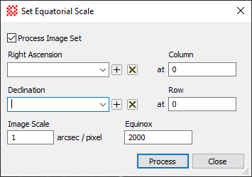
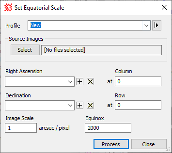
The Set Equatorial Scale command opens
from the Image Window > Coordinates menu and  button on the Main Toolbar. The "immediate" form, shown first,
opens when an image or image set is displayed in the top-most
window. The general form can be used to select source images from
folders, windows, or by matching templates.
button on the Main Toolbar. The "immediate" form, shown first,
opens when an image or image set is displayed in the top-most
window. The general form can be used to select source images from
folders, windows, or by matching templates.
|
Set Equatorial Scale Properties
|
|
Profile [|>]
|
Selects the parameter profile for this command and
allows you to save or work with existing presets.
|
|
[Select]
|
Opens the Select Source Images dialog to choose images
from an image window, folder, files, name template, or a Mira File
List.
|
|
Right Ascension
|
Enter the right ascension at the specified
Column number.
|
|
Column
|
The column position corresponding to the specified
Right Ascension.
|
|
Declination
|
Enter the declination at the specified
Row number.
|
|
Column
|
The row position corresponding to the specified
Declination.
|
|
Image Scale
|
Enter the image scale in units of arcsecond per
pixel.
|
|
Equinox
|
Enter the equinox for the coordinate system.
Usually this is the number 2000 for the J2000 equinox.
|
The WCS Calibration requires the information shown
in this dialog: (Right ascension, Declination) at a reference
(column, row), an Image Scale, and an Equinox. This command inserts
these quantities into the image header to enable world coordinate
system functionality. This command is usually used to make a low
precision or approximate calibration so that measurements, plots,
and cursor readout can use World Coordinate units of
arcseconds.
This command applies a WCS calibration to the image
or image set. This calibration replaces any existing WCS. However,
this command creates an Undo copy so that you can use the Edit >
Undo (Ctrl+Z) command to restore the previous
coordinate system. To save the equatorial coordinate calibration,
save the image in the normal way.
|
Tip
|
If the  button is pressed
in the active Image Window, the calibration is applied to all
members of the Image
Set. button is pressed
in the active Image Window, the calibration is applied to all
members of the Image
Set.
|
Related Topics
Astrometric Calibration
World Coordinate System
Image Coordinate System
Set Arcsecond Scale
Set Linear Scale
Set Independent Linear Scales
Set Linear Coordinate Units
Delete WCS
Mira Pro x64 User's Guide, Copyright Ⓒ 2023 Mirametrics, Inc. All
Rights Reserved.